http://jytangledweb.org/randomhistorybytes/
Last Update: Wed Aug 02 08:08 EDT 2023
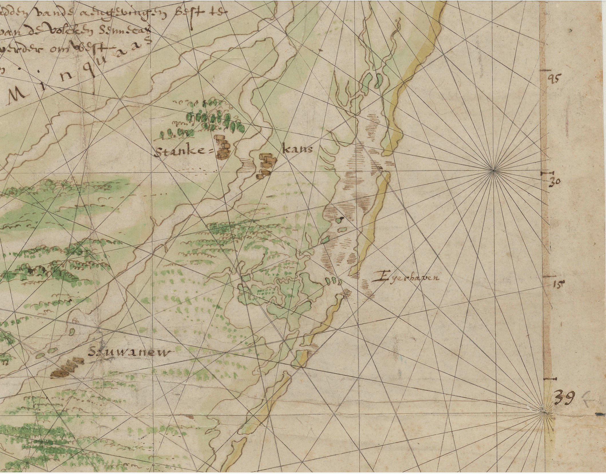
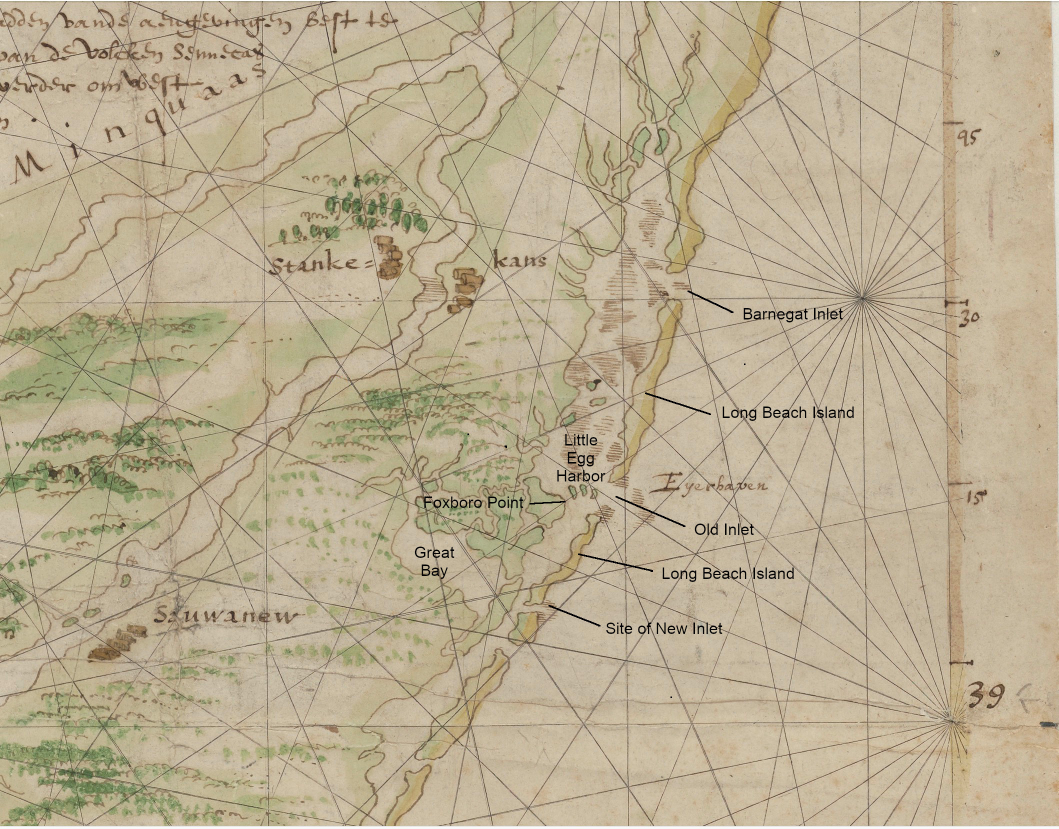
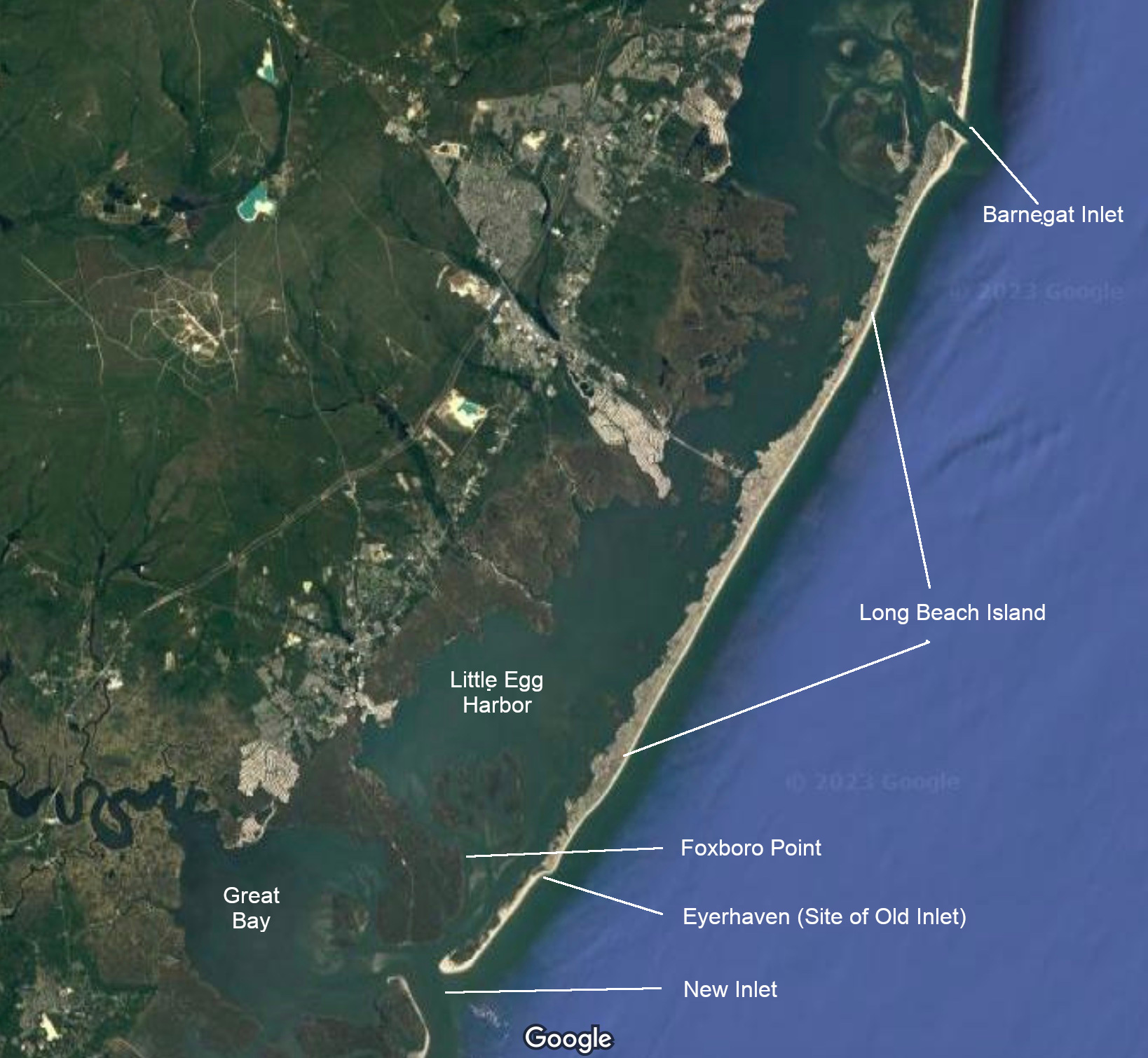
Over a year ago an article in New Jersey Studies: An Interdisciplinary Journal by Douglas T. Aumack titled "Lost and Found: Rediscovering a Seventeenth-Century Map of New Jersey" 1 tells the history of what it describes as "the first complete map of New Jersey." Of particular interest for this article, is that the map is the first detailed mapping expedition done in and around the bays and barrier islands of Little Egg Harbor, Great Bay, and the vicinity. Eyerhaven ("Egg Harbor") 2 is inscribed on the map, 3 and a zoomed image of that section of the map (untouched) is shown on the left side below, and on the right side some labels are added to that map section, and below them is a Google satellite map of the region today, with corresponding labels. (Click on any of the maps for a larger view).
The level of detail indicates that the area was physically explored and mapped, not from a sail by, at a distance, as by other previous visits by Europeans. Little Egg Harbor Bay, Long Beach Island, and Great Bay are all recognizable. The marsh configuration is recognizable, and as we know that changes a lot over the decades and centuries in the barrier island marsh regions.
The 1616 map has the label "Eyerhaven" at what is now known as the Old Inlet. Foxboro Point is inland of the Old Inlet location, and is recognizable and labeled on both the 1616 and satellite maps above. John Bailey Lloyd, in Eighteen Miles of History on Long Beach Island says that in 1800 a storm cut a New Inlet, and the Old Inlet began to shoal up and by 1848 it was navigable at only high tide, and was closed fully by 1874. 4 When the Old Inlet closed, Long Beach Island became continuous from Barnegat Inlet to the New Inlet, as shown in the satellite map above.
Aumack's article explains that the mapping was done by Cornelius Hendrickson from the vessel Onrust, one of the first boats built in North America. How this came about is an interesting tale.
Henry Hudson, in 1609, had explored and claimed New Netherland for the Netherlands. The Dutch began trading with the Indians there for beaver pelts, and it became a very lucrative business. Adriaen Block was captain of the trading ship Tijger (Dutch for "Tiger") in 1614 when the ship accidentally burned while moored at the southern tip of what in now Manhattan.
The crew members then built the new yacht Onrust (Dutch for "Restless") from salvaged and available materials. This smaller boat drew less water and was able to explore shallower areas than larger ocean crossing vessels. This allowed Cornelius Hendrickson to use the Onrust for a two year exploration voyage of what is now New Jersey's coast line, and also up what is now the Delaware River. The detailed features on the 1616 map shown above were able to be explored and mapped because the smaller boat could sail behind the barrier islands, into the many bays, and up the many rivers.
The story of the Onrust is also told in RHB024. 5
An Onrust replica was built by the Onrust Project in 2006. The full story is found on their website and includes many photographs of it and its building, and how to book a sail on it. Here what the site says about the size of the boat 6: "Records also mention the ship was a 'small Yacht of about eight lasts (16-ton burden) and measured 44 1/2 feet in length, with a beam of 11 1/2 feet and a keel of 38 feet long.'"
For many more interesting details, the interested reader is referred to the Aumack article referenced above, the Onrust Project, and the other links provided above. This article is meant only to show and describe the existence of a 1616 very detailed map of the Little Egg Harbor region, and how that came about.